| << | 70 | 71 |
Be sure to hover the mouse over the images.
Pictures and Stories About Bicycle Adventures
Valley of Fires Recreation Area, or Malpais (Bad Country),
and Carrizozo (the Lincoln County Seat), New Mexico:
An Ancient, Non-Volcanic, Lava Flow Opened Through the Earth
Forming a Black on White Contrast in the Tularosa Basin;
Tandem Bicycle Tour;
February, 2019
Day 3
From the Valley of Fires Recreational Area in New Mexico,
We Performed a Loop Ride Eastward to the Town of Carrizozo,
Then We Loop Cycled Westward Through the Ancient Lava Field
(also known as Malpais, Bad Country, Bad Land, or the Valley of Fires)

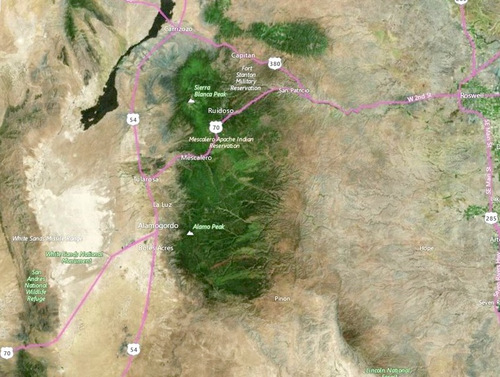
Above Left: The old Lava Field shows itself as a 44 mile long Black Strip on the area map (from Google Maps), it actually crosses and contrasts with the White Sand (of the Military's White Sands Missile Range) in the Tularosa Basin (which is all geologically a part of the Chihuahua Desert that extends north from Mexico).
Above Right: We had parked our motor vehicle in the Parking Lot of the Valley of Fires Recreational Area Visitor's Site and unharnessed the Bee (our da Vinci Tandem Bicycle). We had earlier performed a self-guided walking tour that meandered through the old lava flow, reading most of the information signs and using a route map issued at the Visitor's Center (see the Valley of Fires Side Tour).
Above Left: Here we were, in the parking lot of the Visitor's Center, on the Bee snapping a quick starting photograph looking ESE across the Sacramento Mountains (Sierra Blanca is the tallest).
Above Right: Looking ESE across the Sacramento Mountains (unknowingly capturing a pair of Lenticular Clouds, interestingly, the clouds are over Roswell).
Above Left: We were heading east on US-380, Carrizozo was our destination. US-380 connects the towns of Carrizozo and San Pedro (a small town near Socorro, all towns in New Mexico), but the highway crosses a part of the White Sands Missile Range and every now and then, a portion of the highway (west of here) is closed for Safety Purposes.
Above Right: We quickly noticed a man-made stack of lava rocks parallel to our road on the south side (our riding side) and we stopped to investigate. We discovered a portion of the old highway.
Above Left: We were near the edge of the magma deposit where some streams of the lava flow went around pockets of old land, forming islands of old earth.
Above Right: Terry got off the bike and captured a photo of the entrance sign to the Valley of Fires (Recreational Area).
Above: This was the moment that the Lenticular Clouds registered to my brain.
Above Left: This was the first Street Sign that we cam across heading east toward Carrizozo, notice that a new Lenticular Cloud was forming.
Above Right: A Rich American History in this area.
Above Left: Hefker Ranch - What we liked was the Calf chasing the little child.
Above Right: Challenge Accepted - We have a new mission, find all of Carrizozo's Painted Burros.
Above Left: Just a little about Carrizozo.
Above Right: New Mexico Dust Storm Fence.
Carrizozo
Above Left: We were officially in Carrizozo, New Mexico.
Above Right: N-S US-54, E-W US-380, and the Railroad all meet within 100 yards of each other, which is why this area is important; in the 1800s this area was also a strategically important crossing and depot (which is why Carrizozo became the Lincoln County Seat).
Above Left: The nearest towns in each direction, we turned right, but only for a 1/2 mile or so, so as to return on "Historic 12th Street" (to find Burros).
Above Right: We were following US-54 through town, the Welcome Center was closed, and we found our 1st Burro.
Above Left: Burro #2.
Above Right: Burro #3.
Above Left: We found turned upon 12th Street only to immediately find Burro #4 (Dennis, Terry, and the Bee) - There might be a joke there.
Above Right: I thought it was a pretty cool design.
Above Left: This building is showing its age, it's kind of interesting.
Above Right: Burros #5 and #6.
Above Left: Burro #7.
Above Right: Burro #8.
Above Left: Not a Burro.
Above Right: There are 3 Burros in this picture, all on the left side, however, the Carriage Art Burro does not count (#s 9 & 10).

Above Left: Burros #s 9 & 10.
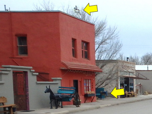
Above Right: #9 is on the roof.
Above Left: A close-up of the Carriage Art Burro (which does not count).
Above Right: The Bee Team and the Carriage Art Burro.
Above Left: There are 5 Burros of the Carrizozo Chamber of Commerce Collection, #s 11-16, 1 pre-existing art Burro (back-left earth-brown), and 3 mini-burros (also earth-brown on the right-side).
Above Right: None of these guys count, but 4 Burros (2 large, 2 small, all earth-brown).
Above Left: Burro #12 was in a shop window - Do catch the Bee-Team reflection waving at you!
Above Right: Burro #13 is on the roof of the newspaper Building.
Above Left: This may be #10, I can't quite remember.
Above Right: We just like the Flag Art (and that is a Sun or Eye Watching Symbol above the Flag).
Above Left: Burro #14 is sponsored by the local Veterinarian.
Above Right: A nice bench and with a little imagination, there may be a Burro or Horse Pattern visible in the center.
Above: Here is another Burrow (but it does not count).
Above Left: The Lutz Building of 1917, it has served many purposes over time, it was the home of the newspaper for a while but now that is either defunct or working out of just a single office, we could not tell, and now it serves as a mix of room or office space rentals.
Above Right: A close-up of Burro #18 on top of the Lutz Building.
Above Left: Burro #19 was in a Photography Studio in a corner display of the Lutz Building.
Above Right: This is a close-up of Burro #2.
Above: Dennis and the Bee next a building mural in Carrizozo, New Mexico (Photo by Terry). This ended the Burro Hunt.
Above: This is the RayLee Diner at the intersection of US-54 and US-380 (where we had lunch and plenty of entertainment from friendly local families with kids).
Above Left: We turned Left from US-54 onto US-380.
Above Right: The Valley of Fires was straight ahead, due west.
Above Left: A road sign about the Malpais (Valley of Fires).
Above Right: On the flip side of the information sign were other Points of Interest in the area (all north of here).
Above Left: Heading West, the ancient lava field is now visible.
Above Right: Looking North at the Jicarilla [Apache] Mountains (zoomed-in).
Above Left: Looking North at the Jicarilla [Apache] Mountains.
Above Right: Our starting point is a mile ahead but we will continue straight.
Above Left: The circle of life.
Above Right: Moses and the Malpais.
Above Left: The handlebar bag tour continues (no map today).
Above Right: This was our starting point but we're riding through the Malpais.
We Just Turned the Bee (da Vinci Tandem) Around and Are Now Eastbound for the Valley of Fires Recreational Area
Above Left: A final look at the Sacramento Mountains.
Above Right: We returned to the starting area by the Visitor's Center of the Valley of Fires Recreational Center.
We had a pleasant day just riding and being together.
From here we headed north to see the Coronado Expedition Visit Site, located just north of Albuquerque.
Tease: The 'Francisco Vázquez de Coronado y Luján' Expedition continued north through what is now
New Mexico (from Mexico) and made it through parts of Texas, Kansas, and Oklahoma
in 1540 through 1542. See our side trip at Coronado and Two Ancient Pueblos.